Satellite images point to almost 59,000 buildings possibly damaged after earthquakes in Venezuela
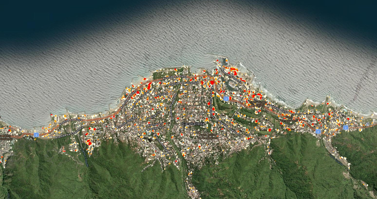
The analysis has not yet been compared with on-site inspections or with detailed records made by emergency teams.
NASA
A preliminary analysis carried out by researchers at Oregon State University, in the USA, estimates that around 58,900 buildings may have been damaged or destroyed by the strong earthquakes that hit Venezuela last Wednesday (24).
The survey was produced with satellite images captured after the tremors and points out the areas where there is a greater possibility of damage (see ABOVE).
Favorite g1 on Google and follow the main news of the day
The earthquakes occurred in northern Venezuela, near the cities of San Felipe and Yumare. The first tremor had a magnitude of 7.2 and was followed by another, of magnitude 7.5.
The tremors were also felt strongly on the central coast and in the metropolitan region of Caracas.
Download the g1 app to see news in real time and for free
The survey shows a greater concentration of possible damage in the areas that recorded the most intense tremors, mainly in the coastal strip and in the urban corridor that reaches the Venezuelan capital.
NASA warns, however, that the number does not represent a definitive count of the buildings affected.
The analysis has not yet been compared with in-person inspections or with detailed records made by emergency teams.
Now on g1
To arrive at the estimate, images taken before and after the earthquakes were compared.
The survey was produced by researchers at Oregon State University, in the United States, using data from the European Sentinel-1 satellite.
The estimate considers the areas observed until the most recent passage of the equipment, carried out on Thursday morning (25).
The system looks for sudden changes in the surface, such as those that could be caused by landslides, displacement of debris or damage to buildings.
One of the images was captured on Wednesday night and covered the region closest to the epicenters. Another was recorded on Thursday morning (25) and included Caracas and populated areas of the capital, such as Petare and Antímano.
Buildings destroyed by earthquakes in Caraballeda, in the state of La Guaira, Venezuela, on June 27, 2026.
Federico Parra/AFP
The analysis managed to evaluate around 75% of the land area included in the survey. Some stretches were not observed because they were outside the path of satellites or were in regions with few buildings.
Very small buildings or those located very close to each other may also not have been identified separately.
According to those responsible for the survey, the data should be used to help locate areas with a greater possibility of destruction and guide more detailed assessments.
Confirmation of the situation of each building depends on higher quality images and inspections carried out on the ground.
READ ALSO:
Stress on the San Andreas and San Jacinto faults is at the highest level in a thousand years, says study
Europe faces heat wave with deaths, record temperatures and impacts on the economy
What is behind the heat wave in Europe associated with 1,300 deaths
Heat wave in Europe moves to the east of the continent
Source: G1