Heavy rains cause flooding and leave Salvador in a state of alert
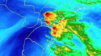
After a weekend marked by intense rain, Salvador is under observation. Although the weather system, known as cavado, began to lose strength on the afternoon of this Monday (1st), the morning was still very disruptive for residents of the capital of Bahia, with records of flooding and incidents related to bad weather.
According to Cemadec (Civil Defense Alert and Alarm Monitoring Center of Salvador), the trend is for a reduction in rainfall between this Monday and Tuesday (2). However, the arrival of a new cold front should change the scenario again from Wednesday (3), a factor that should cause storms, in addition to gusts of wind.
According to Codesal (Civil Defense of Salvador), around 160 millimeters of rain were recorded in the city in the last 72 hours. Over the weekend, wind gusts reached 45 km/h.
For comparison purposes, winds of up to 20 km/h are considered weak, while speeds of up to 30 km/h are classified as moderate.
The trough, a phenomenon responsible for the instability observed in recent days, favors the formation of large volumes of rain, as well as lightning, thunder and intense winds. Despite this, there were no records of electrical discharges or thunderstorms during the period.
"Each year, rainfall volumes increase as a result of climate phenomena, which requires governments around the world to invest more in meteorological, geotechnical, hydrological and pluviometric stations, as well as slope protection and containment technologies, among other actions that contain coastal erosion and measures that make cities safer and more resilient", explained the general director of Codesal, Adriano Silveira.
Rain forecast is dominant in much of Brazil | CNN NEW DAY
As of Monday morning, Codesal had recorded 68 incidents due to rain, including assessments of flooded properties, landslides and broken runways. The Civil Defense teams reinforced that, in case of emergency, the population should contact the agency by calling 199.
Source: CNN