El Niño has arrived and could be "very strong", says US agency
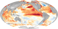
El Niño has officially begun and is forecast to intensify, becoming a "Super El Niño", with major changes in global weather patterns and an even warmer climate, according to a new report released this Thursday morning (11) by NOAA (National Oceanic and Atmospheric Administration).
El Niño is a periodic weather pattern in the tropical Pacific Ocean that alters winds and features exceptionally warm waters in the central and eastern Pacific. These changes in winds and ocean temperatures have cascading effects on weather patterns around the world.
NOAA's Climate Prediction Center gives this El Niño a 63% probability of becoming a "very strong" event (popularly known as a Super El Niño) and one of the "largest El Niño events recorded historically since 1950."
In a sign of the center's certainty in its forecast, it assigns a 100% probability of El Niño continuing through the fall and extremely high odds of it continuing through the winter.
To be considered a Super El Niño, water temperatures in the tropical Pacific must be more than 2 degrees above average. Some reliable computational models suggest that this limit will be largely exceeded.
In recent months, large volumes of exceptionally warm water have been moving from the western Pacific to the eastern tropical Pacific, driven by changing wind directions.
This exceptionally warm water has traveled to a depth of about 180 to 300 meters below the ocean's surface and is beginning to surface thousands of kilometers to the east, closer to South America. Similar dynamics have occurred during intense El Niño events in the past.
Super El Niño events are relatively rare, with the most recent occurring in 2015-16, 1997-98 and 1982-83.
Because El Niño involves the transfer of a large amount of thermal energy from the ocean to the atmosphere, this phenomenon also has implications for global climate.
It raises global average surface temperatures, in addition to the warming trend caused by fossil fuel pollution, virtually guaranteeing that 2027 will surpass 2024 and set a new record as the planet's hottest year.
How the Climate Prediction Center monitors El Niño
To measure El Niño, the Climate Prediction Center uses the Niño Ocean Index - a three-month moving average of sea surface temperature anomalies in the "Niño region" of the Pacific Ocean. At least four "very strong" El Niños (or "Super" El Niños) occurred during this period.
See:
El Niño monitoring chart - CNNi
How El Niño can affect you
El Niño increases the likelihood of certain extreme weather events, including heat waves, floods and droughts, depending on location. In the US, its impacts are most evident during the winter months.
North America
Hurricanes: Although El Niño can intensify the hurricane season in the central and eastern Pacific, it tends to limit the number of hurricanes in the Atlantic. Stronger El Niños like this one tend to increase the likelihood of these effects occurring.
The connections between hurricane season storms could pose problems for the U.S. Southwest and Hawaii, depending on the path each storm takes.
Winter in the US: Above average temperatures are typically observed from the northern US to western Canada and Alaska, although this does not exclude occasional periods of colder weather. The southern US tends to be wetter and colder, as a more active jet stream directs more storms to that area.
- California may see atmospheric river events more frequently as the moisture-laden jet stream reaches the coast, although it is difficult to predict which part of the state will be most affected.
Floods, heat and drought: Some regions, such as Australia and Indonesia, are prone to droughts and heat waves during El Niño, which can lead to wildfires and water supply problems.
- In summer, monsoon rains decrease in India and Southeast Asia, and there are already signs that this is starting to happen. Reduced precipitation in these areas can worsen summer heat extremes.
- The Caribbean also tends to suffer from droughts during El Niño. Warm, dry winters are typical in parts of southern and eastern Asia.
Drought may intensify in southeast Africa during the Southern Hemisphere summer, from December to February. Meanwhile, areas closer to the Horn of Africa may experience torrential rain between October and January.
South America
A part of southeastern South America tends to experience more intense rainfall during El Niño years, while southeastern Brazil experiences above-average temperatures. A swath of northern South America, extending into parts of Central America, tends to be drier than average from July to December.
Northwestern South America, including Peru, is prone to intense rainfall due to El Niño during the period January to May, given its proximity to exceptionally warm ocean waters.
- Oceans: El Niño events can lead to widespread marine heatwaves and coral bleaching, making corals more sensitive to higher ocean temperatures. Marine heat waves themselves can also influence regional weather patterns.
- Economic impacts: Studies have shown that intense El Niño phenomena can reduce economic growth in countries due to losses caused by disasters, disruptions in food supplies and other effects.
But that's not all: individual El Niño events, even very strong ones, do not follow exactly the predicted impact pattern, and there will be surprises.
There is an extra dose of uncertainty about the impacts of this Super El Niño because this event is occurring at a time when the world is already much warmer than average due to global warming caused by fossil fuel pollution, so there are some questions about how this could intensify El Niño-related extreme weather events.
In short, there has never been an El Niño, let alone a Super El Niño, when the background climate was as warm as it is now.
CNNi meteorologist Chris Dolce contributed to this report.
Source: CNN