BEFORE and AFTER: satellite images show destruction after earthquakes in Venezuela
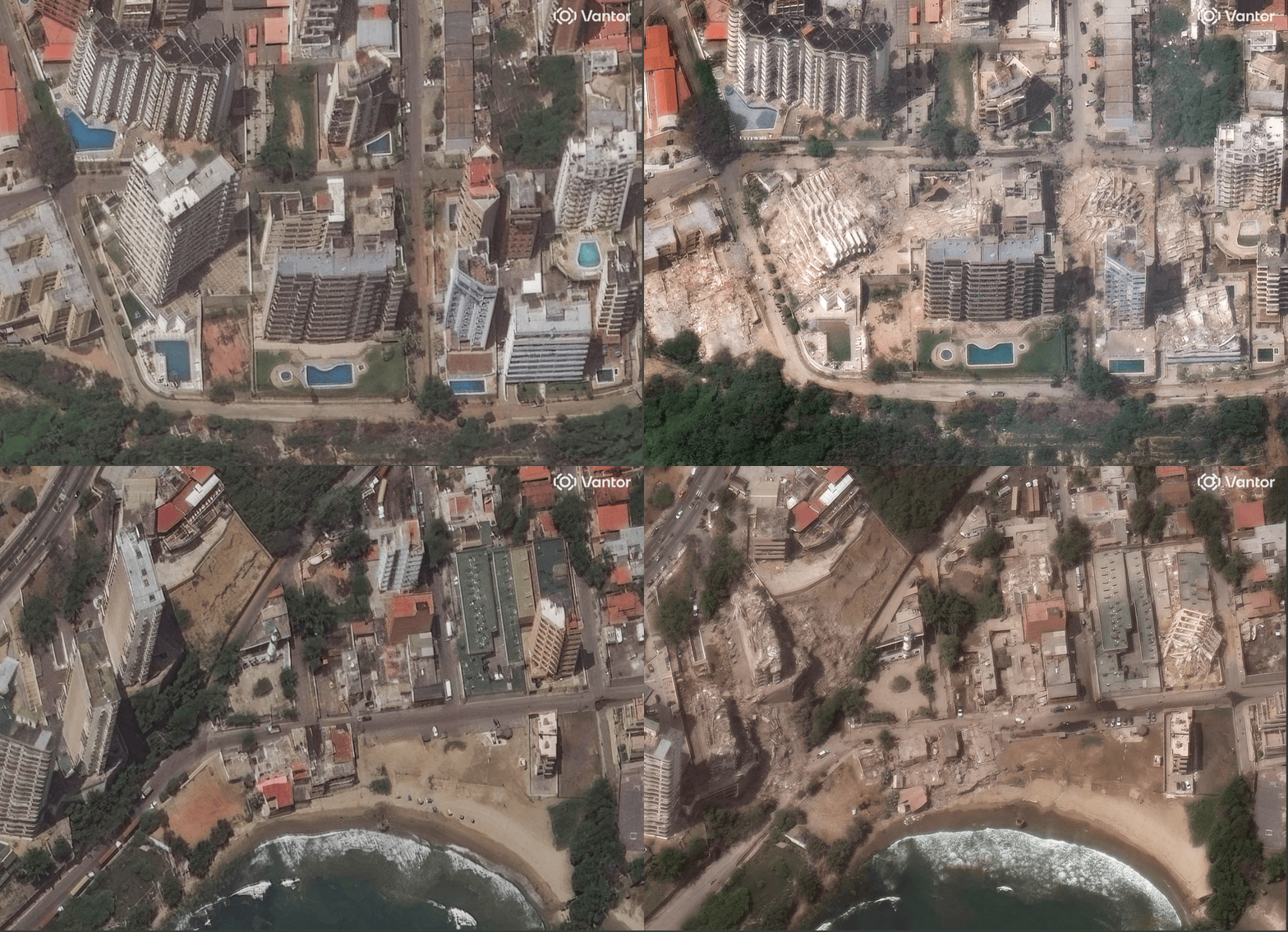
Satellite images show before and after earthquake in La Guaira, Venezuela
Images released by the space intelligence service Vantor show the before and after of cities hit by the earthquake in Venezuela, on Wednesday (24). The photos reveal collapsed buildings and destruction, mainly in La Guaira.
LIVE: see the latest earthquake updates
✅ Follow the g1 international news channel on WhatsApp
▶ Context: Two tremors of magnitudes 7.2 and 7.5 were recorded on Wednesday night (24), at an interval of less than a minute. Until the last update of this report, authorities confirmed 188 deaths and 1,520 injuries.
Compare the satellite images below.
Buildings in La Guaira
Before the earthquake
Buildings before the earthquake in La Guaira, Venezuela
Satellite image ©2026 Vantor
After the earthquake
Buildings collapsed in La Guaira, Venezuela, after earthquake
Satellite image ©2026 Vantor
Buildings on La Guaira beach
June 22
Buildings on La Guaira beach, Venezuela, on June 22, 2026, before earthquake
Satellite image ©2026 Vantor
June 25
Buildings collapsed on La Guaira beach, Venezuela, after earthquake June 24, 2026
Satellite image ©2026 Vantor
Residential area in La Guaira
Before the earthquake
Residential area in La Guaira, Venezuela, before the earthquake
Satellite image ©2026 Vantor
After the earthquake
Satellite shows damaged residential buildings after earthquake in La Guaira, Venezuela
Satellite image ©2026 Vantor
Deposit in La Guaira
Before the earthquake
Deposits in La Guaira before the earthquake
Satellite image ©2026 Vantor
After the earthquake
Depots collapsed after earthquake in La Guaira, Venezuela
Satellite image ©2026 Vantor
Industrial area in La Guaira
May 8
Satellite image from May 2026 before earthquake in La Guaira
Satellite image ©2026 Vantor
June 25
Industrial area in La Guaira on June 25, 2026, after earthquake
Satellite image ©2026 Vantor
The earthquake
On Wednesday night, strong earthquakes hit the north coast of Venezuela causing large-scale destruction and tsunami warnings in the region.
The United States Geological Survey (USGS) reported that the tremors had magnitudes 7.2 and 7.5. They occurred less than a minute apart.
The city of La Guaira, near Caracas, is the most affected and has been classified as a "disaster zone". The interim president, Delcy Rodríguez, declared a state of national emergency.
Satellite images show before and after earthquake in Venezuela
Satellite image ©2026 Vantor
VIDEOS: most watched on g1
Source: G1