


Leia a noticia completa
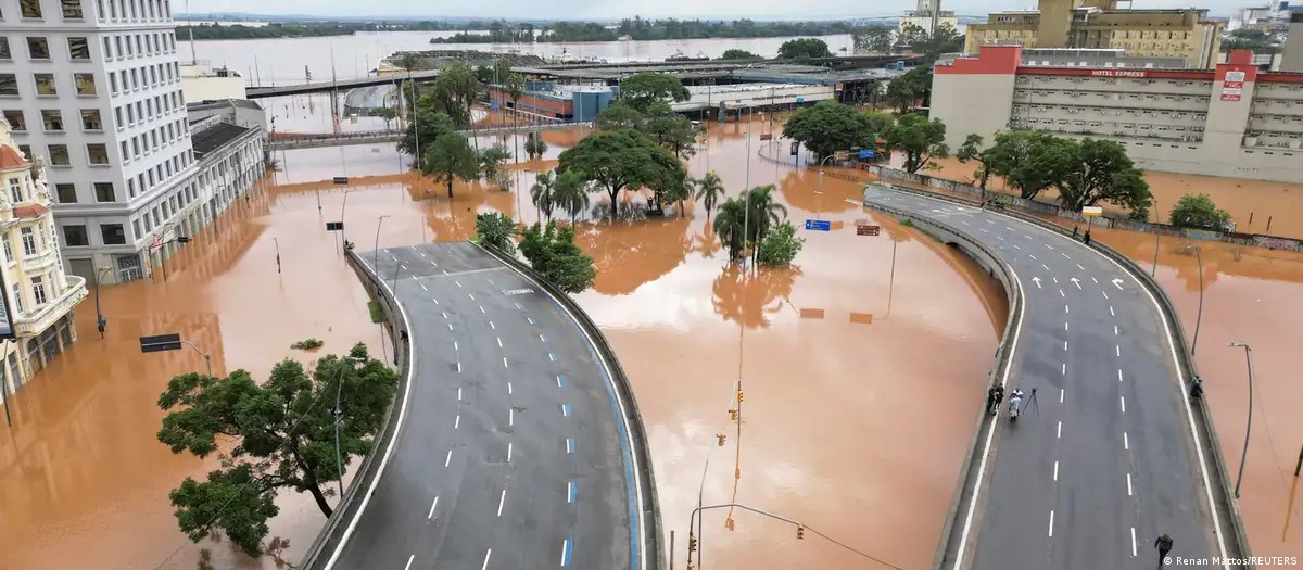
Extreme rain in Rio Grande do Sul in 2024, caused by overlapping climatic events, including El Niño
Renan Mattos/REUTERS via DW
A new episode of El Niño is already showing signs in the Pacific and could bring more rain to the South and drought to the North and Northeast. There are still doubts about the intensity of the phenomenon, amid the lack of preparation and adaptation in the country. From above, satellites and radars monitor the mass of warmer water that moves across the Pacific Ocean towards the coast of South America.
This monitoring, reinforced by buoys at sea, indicates a pattern already known to researchers: another El Niño is in the making. The main uncertainty now is about its intensity.
"The term 'super El Niño' is not exactly appropriate", says Tércio Ambrizzi, professor of atmospheric sciences at the University of São Paulo (USP). "The tendency is for it to be moderate to strong", he comments on a certain consensus in the scientific community.
The phenomenon is usually identified when the surface temperature of the Pacific Ocean, in the equatorial region, remains around 0.5 °C above normal for a prolonged period, generally at least three months. Since February, measurements have shown this increase in the region.
Now on g1
Scientists are still awaiting confirmation of where the greatest warming will occur in the ocean. This factor will be decisive in defining how the impacts will be felt in Brazil.
"Compared to others in the past, it is possible that the first signs of this El Niño should appear in the South of Brazil during the spring, with more rain", says José Marengo, general coordinator of Research and Development at the National Center for Monitoring and Alerting of Natural Disasters (Cemaden).
According to the World Meteorological Organization (WMO), there is a 90% probability of El Niño occur again this year. It can have strong intensity, which tends to worsen both droughts and intense rains, in addition to increasing the risk of heat waves on land and in the ocean.
"El Niño conditions will throw more fuel on the fire of a world that is warming and its impact will be even more severe, it will reach further and cross borders with devastating speed", warned the United Nations scientific body last Tuesday (02).
Between the end of April and mid-May, sea surface temperatures in the Pacific area used as a reference were already approaching typical El Niño levels. This scenario was reinforced by temperatures below the surface more than 6 ºC above average.
It is never the same
The possible emergence of a strong El Niño has sparked debates across the country. In the National Congress, sessions discuss whether its impacts could harm the population, the economy and agribusiness.
The next grain harvest, for example, is estimated at 356 million tons, which represents an increase of 1.2% compared to the previous harvest.
To DW, the Civil Defense of the Union, linked to the Ministry of Regional Development, reported that it monitors climate conditions daily in conjunction with states, municipalities and institutions such as Cemaden and the National Institute of Meteorology (Inmet).
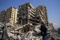
Conditions generated by El Niño can facilitate fires and impact agricultural production
Michael Dantas/AFP via DW
"There is still no precise prognosis on the impacts of the phenomenon. Therefore, action is focused on constant monitoring and advance preparation so that, if more critical situations are expected, the necessary alerts and measures are adopted in a timely manner", responded the agency, in a note.
If the phenomenon is confirmed, a worsening of the drought during the winter and early summer in some regions, such as the North - especially in the Amazon - and part of the Northeast. These conditions can favor fires and affect agricultural production. In the South, there is a forecast of increased rainfall.
"Each El Niño has its own fingerprint. It is never the same as the other", says Ambrizzi.
The most recent episode of El Niño occurred between 2023 and 2024 and was one of the five most intense recorded, which influenced the occurrence of record global temperatures.
The outskirts of Porto Alegre were hit hard by the events of 2024
Gustavo Basso/DW
The memory of the destruction caused by extreme rains in Rio Grande do Sul in 2024 is still fresh. That year, a combination of climatic events, including an intense El Niño, caused the worst flood in the state's history.
"Governments and authorities in general seem more concerned. But this alone is not enough. Even if the El Niño is not intense, the atmosphere is already warmer, there is already global warming, which should already be causing changes in a more systematic way", points out Marengo.
Absence or little preparation
In the most vulnerable communities, there is the perception that there was a lack of public investment to adapt and cope with rain or extreme droughts intensified by El Niño.
"The outskirts of cities are already suffering from the accumulated impacts of several disasters. We have almost nothing ready to adapt our communities to this scenario", says Thaynah Gutierrez, executive secretary of the Anti-Racist Adaptation Network, citing the outskirts of Porto Alegre, heavily hit by the events of 2024.
For experts in risk management, preparation for extreme weather events should not depend on confirming a specific phenomenon. It should be part of a continuous planning agenda.
Although there have been advances in raising awareness in public bodies, the private sector and civil society, the debate still tends to focus on what exactly will happen: whether there will be drought, intense rains or floods.
The focus, however, should be on building a permanent capacity for adaptation.
"More than reacting to each new alert, regardless of the occurrence of a specific event, territories must be prepared. The focus needs to be on the resilience of cities, infrastructure and of productive systems", suggests Victor Marchezini, sociologist at Cemaden and coordinator of the Organizational Capabilities for Preparedness for Extreme Events Project supported by the São Paulo State Research Support Foundation (Fapesp).
Dangerous alarmism
Another challenge is in risk communication. With the multiplication of meteorological analyzes on social networks - often produced by private consultancies and influencers with different interests - the population is exposed to conflicting information.
"This excess of messages can generate doubts about which forecasts are more reliable and which concrete measures should be adopted", criticizes the sociologist.
Graduated in public administration, Gutierrez follows the alarmism generated by forecasts, but states that the majority of the population does not access this type of content - except through videos that go viral on the internet.
"In general, governments and institutions lack situated knowledge of which territories are the most vulnerable. We want to talk about this in a responsible way and demand that governments prioritize these territories in preparation", he argues.
The responsibility for demanding investments and being accountable needs to be part of all spheres of government, as well as planning, adds Marchezini.
"This would allow, for example, the early execution of tenders and contracts for disaster response, reducing the need for emergency measures and extraordinary expenses when crises are already underway", he comments.
In light of the forecasts, Santa Catarina, for example, declared a state of climate alert, valid until November. At the same time, the state government practically paralyzed investments in disaster prevention, according to data from the Integrated Fiscal Planning and Management System (Sigef-SC), released by the state Legislative Assembly.
In 2025, only 15.4% of the resources foreseen in the budget of the Secretariat of Civil Defense and Protection were executed.
The volume allocated to the construction, expansion and renovation of dams was even smaller: only 0.66% of the total was committed.
"It is worth remembering that we are in an election year. We cannot continue electing these politicians who will use the resources that should go to preparing and adapting to extreme events for diversions", comments Gutierrez.
Source: G1

Senate should start discussions on ending the 6×1 scale this week
The proposal to end the 6×1 scale - six days of work and one day of rest - should begin to be debated by senators this...
Iran arrives in Mexico for the World Cup amid visa impasse
Iran arrived early this Sunday (7) in Tijuana, Mexico, to begin preparations for the 2026 World Cup. The delegation di...
Wesley is cut from the Brazilian team after injury and is out of the World Cup
Wesley was cut from the Brazilian team this Sunday (7), due to an injury to the adductor muscle of his left thigh in t...

Toque agora.


Historias das musicas em destaque
 Historia da musica
Theme from the Soap Opera Rei do Gado: learn to play a notable song from Brazilian music
05/06/2026
Theme from the soap opera Rei do Gado, performed by Orquestra da Terra in CifraNet, is a song that carries a strong Brazilian identity,...
 Historia da musica
For You Stay by Talita Ribeiro: learn to play a romantic song full of feeling
05/06/2026
Para Você Ficar, by Talita Ribeiro, is a romantic song that talks about vulnerability, reunion and the courage to declare a feeling eve...
 Historia da musica
Red Rubber Ball by Cyrkle: learn to play a pop classic with a light and nostalgic atmosphere
05/06/2026
Red Rubber Ball, by Cyrkle, is a song that crosses generations with its light, melodic and optimistic sound. Even though it is about fa...
 Historia da musica
It Makes It Rain by David Quinlan: learn to play a worship classic on guitar
05/06/2026
Faz Ver, by David Quinlan, is one of the best-known worship songs among Christian musicians who seek simple, intense and spiritual repe...
 Historia da musica
Bottle 600 of Netto and Henrique: learn to play a country tune full of emotion
05/06/2026
Garrafa 600, by Netto and Henrique, is one of those country songs that mix regret, longing and that bar table atmosphere that speaks di...
 Historia da musica
Heaven's Not For Saints: Learn to Play A-Ha's Hit and Understand What Makes This Song So Special
05/06/2026
A-Ha is one of the most memorable bands in the history of world pop, known for creating music that spans generations with engaging melo...
 Historia da musica
Psalm 107: learn to play Samara Lourenço in a song of gratitude
05/06/2026
Psalm 107, by Samara Lourenço, is a song of praise inspired by gratitude, God's faithfulness and the recognition of his wonders. The so...
 Historia da musica
Só Por Amor A Ti: learn to play Ana Paula Valadão in a song of dedication and faith
05/06/2026
Só Por Amor A Ti, by Ana Paula Valadão, is a profound song of praise, marked by delivery, obedience and devotion. The song talks about...
 Historia da musica
De Bem Com a Vida: learn to play Os Serranos in a happy and passionate song
05/06/2026
De Bem Com a Vida, by Os Serranos, is a light, lively and romantic song. With positive lyrics and a melody that conveys joy, the song i...
 Historia da musica
January 6, 2003: learn to play Fernando and Sorocaba on the guitar
05/06/2026
6 January 2003, by Fernando and Sorocaba, is a country song full of longing, memory and emotion. The lyrics talk about a date that was...
Mais noticias para voce
Noticia
07/06/2026
Dona Francisquinha, from the profile "O Bom do Alzheimer", dies aged 91
Viral influencer of the profile "O Bom do Alzheimer", Dona Francisquinha passed away last Friday (5), aged 91. The death was reported on Instagram created by th...
 Noticia
07/06/2026
Antonelli tours Monaco and remains the absolute leader of Formula 1
Antonelli continues to excel in Formula 1. The Italian won the Monaco GP this Sunday (7). Lewis Hamilton. from Ferrari and Hadjar, from Red Bull, completed the...
 Noticia
07/06/2026
Trump says Iran's new supreme leader is 'more rational'
US President Donald Trump said in an interview with NBC that he believes Iranian Supreme Leader Mojtaba Khamenei is "more rational" than his predecessor. "Young...
 Noticia
07/06/2026
Sniffer dog locates 300 kg of drugs in a community in the South Zone of SP
Around 294 kilos of drugs were found by the Military Police sniffer dog, Gláudios, during an operation carried out in the Community of Arrebento, in the South Z...
 Noticia
07/06/2026
War will test limits for airlines and passengers, says Quest
Commercial aviation is experiencing a kind of Sisyphean curse. Whenever the sector seems to enter a sustainable path, the forces of geopolitics and economics pu...
 Noticia
07/06/2026
Trump reinforces support for Netanyahu, but calls for more precise attacks in Lebanon
US President Donald Trump said he and Israeli Prime Minister Benjamin Netanyahu are on the same page, despite some disagreements between the leaders over Israel...
Participe da conversa
Seu comentario ajuda a manter a discussao viva e ainda convida outros leitores a continuar navegando pelo portal.
Seja o primeiro a comentar esta noticia.