



Leia a noticia completa
The advance of warming in the waters of the Equatorial Pacific Ocean reinforced signs of the formation of a new episode of El Niño and led the United States National Oceanic and Atmospheric Administration (NOAA) to raise the level of attention to the phenomenon.
The most recent update from the Climate Prediction Center (CPC), released on May 18, points to increased confidence in climate models and indicates that El Niño could begin in the coming weeks.
Although the phenomenon has not yet been officially declared, NOAA is already operating at the "El Niño Alert" level (El Niño Watch), a stage that indicates increasingly favorable conditions for the development of the climate event. The current scenario points to a rapid transition from the neutral conditions observed in recent months to a pattern of sustained Pacific warming, according to the NOAA analysis.

End of the 6x1 scale: Chamber committee approves PEC that reduces working hours and increases days off
End of the 6x1 scale: Chamber committee approves PEC textThe special committee that discusses the Proposed Amendment t...Trump commented on Lula during a meeting with Flávio Bolsonaro
US President Donald Trump commented on Lula with Flávio Bolsonaro (PL-RJ) during the meeting with the senator and pre-...
Santos will play friendlies in Europe during the World Cup break; see program
Santos announced, in the early afternoon of this Wednesday (27), that it will go on a tour to Portugal during the foot...
According to the agency's most recent projection, there is an 82% chance of El Niño forming between May and July 2026. The probability of the phenomenon remaining active between December 2026 and February 2027 reaches 96%, a period that corresponds to summer in the Southern Hemisphere.
The Pacific warmed and reached the level associated with El Niño
Behind the change in projections is the behavior of the ocean. The most recent data show that surface warming has advanced in virtually all monitored regions of the Equatorial Pacific.
In the previous report, from May 13, the positive temperature deviations were in:
Toque agora.



- Niño 4: +0.5°C
- Niño 3.4: +0.4°C
- Niño 1+2: +1.0°C
In the most recent update, on May 18, the values increased to:
- Niño 4: +0.6°C
- Niño 3.4: +0.5°C
- Niño 1+2: +1.3°C
The highlight is the Niño 3.4 region, considered the main area for monitoring the phenomenon. The index reached +0.5°C, a level used by NOAA as a reference to characterize conditions compatible with El Niño, as long as warming is sustained and accompanied by consistent atmospheric responses.
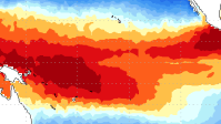
Temperature deviations according to a NOAA report, dated May 18, 2026 - Reproduction/NOAA
The maps presented by NOAA show that warming is no longer concentrated only in the far east and has started to spread across the central and eastern Pacific, a pattern frequently observed at the beginning of El Niño events. The material also highlights that positive temperature anomalies have become more established in these areas over the last few weeks.
The most important signal is below the surface
In addition to the warming observed at the surface, meteorologists monitor an indicator considered even more relevant: the temperature of subsurface waters.
Image from the NOAA report on ocean temperatures - Reproduction/NOAA
According to NOAA, the ocean's heat content increased for the sixth consecutive month, indicating an accumulation of energy below the surface of the Equatorial Pacific.
Analyzes show significantly above-average temperatures across large areas of the ocean, especially in the center and east of the basin.
This process usually precedes the strengthening of El Niño because the heat stored at depth tends to gradually migrate to the surface and fuel the warming of surface waters.
The report also points out that ocean waves known as Kelvin waves have continued transporting heat towards the east of the Pacific since the end of 2025, favoring the maintenance of positive anomalies.
Intensity is still uncertain, but a strong event scenario has gained ground
Although NOAA has increased confidence in the formation of the phenomenon, there is still no definition of its maximum intensity.
The most recent projections indicate that between November 2026 and January 2027 there is about a two-thirds chance of the phenomenon reaching strong or very strong intensity, although there is still the possibility of a more moderate event.
Experts emphasize that more intense events do not automatically mean more severe impacts, but they increase the likelihood of important changes in global temperature and rainfall patterns.
In Brazil, historically, El Niño episodes tend to favor increased rainfall in the South and drier periods in areas of the North and Northeast, in addition to influencing the distribution of temperatures in different regions of the country.
Still, the specific effects of this new episode should become clearer in the coming months, as the warming of the Pacific advances and the phenomenon is officially defined.
New wave of cold and less severe winter
To CNN Brasil, meteorologist from Nottus Alexandre Nascimento stated that the cold recorded at the beginning of May is as expected for the time of year, although it arrived a little later than usual. According to him, the polar mass associated with the cold front managed to advance to the south of the Amazon, causing the phenomenon known as cold weather.
Nascimento also stated that the winter of 2026 should be less severe than last year due to the formation of the El Niño phenomenon. According to the expert, the end of autumn and the beginning of winter should still see new masses of polar air, but July and August tend to have above-average temperatures.
Source: CNN

Historias das musicas em destaque
 Historia da musica
Learn to play Chega, the country music that turns pain into a new beginning
27/05/2026
Chega, by Zezé Di Camargo & Luciano, is one of those songs that speak directly to those who are tired of suffering for love. The lyrics...
 Historia da musica
Learn how to play Total Eclipse Of The Heart, Bonnie Tyler's classic that chills the guitar
26/05/2026
Total Eclipse Of The Heart is one of those songs that seems to be born ready to move people. In Bonnie Tyler's striking voice, the song...
 Historia da musica
Learn to play Memonça Boa on the guitar and feel the strength of this passionate fashion
26/05/2026
Membrança Boa, by Traia Véia, is one of those songs that seem simple, but reach straight to the heart. The song talks about the end of...
 Historia da musica
Learn to play Bete Balanço: the Frejat classic that has energy, attitude and an unforgettable chorus
25/05/2026
Bete Balanço is one of those songs that carries movement from the first chord. With lyrics full of image, dreams, risk and youth, the s...
 Historia da musica
Learn to play Star, by Simply Red, the chord that transforms feelings into guitar
24/05/2026
Star, by Simply Red, is one of those songs that mix romanticism, regret and a striking melody, perfect for those who like to play somet...
 Historia da musica
Learn to play Die With a Smile: the emotional ballad by Lady Gaga and Bruno Mars that conquered the world on guitar
24/05/2026
"Die With a Smile" is one of those songs that already looks like a classic. In the meeting of two giant voices of pop music, Lady Gaga...
 Historia da musica
Learn to play Rasgando a Madrugada, Eduardo Costa's perfect song for guitar
24/05/2026
Rasgando a Madrugada, by Eduardo Costa, is one of those songs that seem to be born in the silence of the night. The song carries the we...
 Historia da musica
Learn to play Autor Da Vida, the Oficina G3 classic that speaks straight to the heart
23/05/2026
Learn to play Autor Da Vida, the Oficina G3 classic that speaks straight to the heart Autor Da Vida, by Oficina G3, is one of those son...
 Historia da musica
Learn to play Te Esperando: the exciting country music by Luan Santana that made Brazil sing on the guitar
23/05/2026
Te Esperando, by Luan Santana, is one of those country songs that sticks in your memory because it mixes romanticism, longing and the p...
 Historia da musica
Learn to play Hey Joe: the Jimi Hendrix classic that every guitarist dreams of mastering
23/05/2026
Few songs carry as much attitude and history as Hey Joe, immortalized in the voice and guitar of Jimi Hendrix. With an unmistakable int...
Mais noticias para voce
 Noticia
27/05/2026
Renewable energy sector demands presidential candidates for transition goals
More than 20 entities and companies in the renewable energy sector presented, this Wednesday (27), a letter addressed to pre-candidates for the Presidency of th...
 Noticia
27/05/2026
Google: see what the interior of the new research center in SP looks like
Google opened this Wednesday (27) an Engineering Center in São Paulo - the second in Brazil. There, technologies involving artificial intelligence and digital s...
 Noticia
27/05/2026
Homeless people in Paris demand shelter amid record heat
Dozens of homeless people gathered in Paris on Wednesday (27) to demand more places in shelters and emergency housing, amid an unprecedented heat wave that hit...
 Noticia
27/05/2026
Madonna partners with company to provide housing for artists in NY
Singer Madonna, 67, announced a partnership with the company Bilt to finance housing for artists in New York. The technology company is focused on member member...
Noticia
27/05/2026
Learn to play Chega, the country music that turns pain into a new beginning
Chega, by Zezé Di Camargo & Luciano, is one of those songs that speak directly to those who are tired of suffering for love. The lyrics bring a strong feeling o...
Noticia
26/05/2026
Learn how to play Total Eclipse Of The Heart, Bonnie Tyler's classic that chills the guitar
Total Eclipse Of The Heart is one of those songs that seems to be born ready to move people. In Bonnie Tyler's striking voice, the song mixes drama, intensity a...
Participe da conversa
Seu comentario ajuda a manter a discussao viva e ainda convida outros leitores a continuar navegando pelo portal.
Seja o primeiro a comentar esta noticia.